

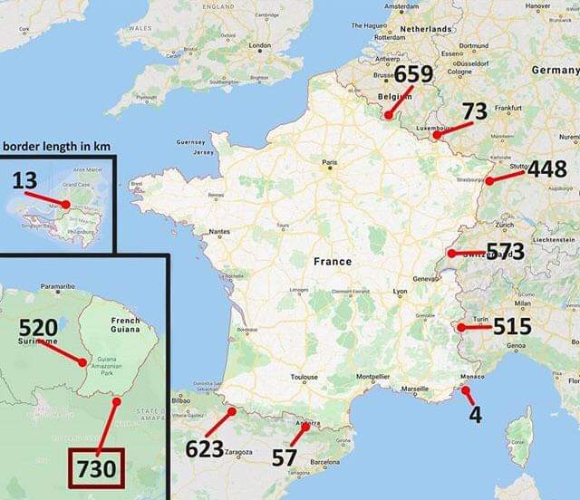
Honestly I’m more surprised that the border with Belgium is longer than the border with Spain
I think it’s just measuring the longest contiguous border.
The border with Spain has Andorra in the middle
There isn’t a 2nd number on the east side of Andorra so I think the 623 is the total with Spain.
Could be or it’s just counting the longest border they share
During the times of Caesar, Belgica started just north of Paris.
Arnt most borders fractals so can any border be the largest?
No, because borders are made up by humans and humans can’t write down or even measure infinitely small
Some borders drawn as straight lines on maps sure. But we also define borders by rivers and all sorts of other fractal things.
Borders are just social construct
We can if we make tools to do it for us.
halting problem
Actually, in this case, it’s easily solved. Trying to measure an infinitely complex curve will never halt, answer found.
No, I can write limits.
It’s kind of subtle how exactly you’re using numbers when writing limits. You’re either not actually doing infinitesimals, just Cauchy sequences centered around a point, or you are and you get to enjoy the axiomatisation of the hyperreals.
You’ll have to represent each border on the same scale, so no. Also, why are you being flagged as a bot?
I was writing a bot and must have accidentally enabled it for my main account. Fuck im retarted.
Even Firefox’s coloured containerisation can’t fix stupid
LIES!!! AI IS TRYING TO INFILTRATE US!!! BURN THE BOT WITCH!!!
Your username is cursed, thanks for bringing that combination of words to life
Don’t thank me, thank chatGPT.
Anyone can just go into their account settings and mark their accout as a bot. Idk why you would though
You would do that if you were running that account using a bot.
Yes, but non-coastal borders become nice curves at a certain resolution just because they’re legally defined by points.
Coastal borders are legally vague AFAIK, since they’re defined as a nautical mile from “the shore” or something like that, but when you’re already on the ocean a matter of a few meters tends not to matter.
considers
Well, they aren’t fractal, that’s for sure.
It is true that we could make borders more-closely-map to physical features, and that would increase the length somewhat.
And we can define borders however we want, so that’s up to us.
But ultimately, matter is quantum, not continuous, so if we’re going to link the definition of a border to some function of physical reality, I don’t think that we can make a border arbitrarily long.
Coastlines are indeed fractals, and a similar argument could be made for any border defined by natural phenomena (so like, not the long straight US/Canada border).
Coastlines are not self repeating and they are fundamentally finite.
I believe they were referring to this, where technically a coast could be seen as similar to fractals
Literally from that page
The coastline paradox is often criticized because coastlines are inherently finite, real features in space, and, therefore, there is a quantifiable answer to their length.[17][19] The comparison to fractals, while useful as a metaphor to explain the problem, is criticized as not fully accurate, as coastlines are not self-repeating and are fundamentally finite.[17]
Fractals are not necessarily self repeating, they just contain detail at arbitrarily small scales.
Which a physical space cannot fulfill
Fractals are not required to be self-repatiing. For example, the Mandelbrot set is a non-self repeating fractal pattern.
And please elaborate on how they are fundamentally finite.
Coastlines exist in the real world, they are by definition finite structures. You can only zoom in to them so far before the structure is no longer a coastline.
Thats making a lot of assumptions about quantum physics
An atom is not a coastline, even if it is a piece of one
deleted by creator
Well, quantum mechanics is continuous, just in a way that often maps to discrete things when measured. I’m sure someone has written a research paper on quantum law, but I wonder if anyone who actually knows quantum mechanics has.
It is only continuous because it is random, so prior to making a measurement, you describe it in terms of a probability distribution called the state vector. The bits 0 and 1 are discrete, but if I said it was random and asked you to describe it, you would assign it a probability between 0 and 1, and thus it suddenly becomes continuous. (Although, in quantum mechanics, probability amplitudes are complex-valued.) The continuous nature of it is really something epistemic and not ontological. We only observe qubits as either 0 or 1, with discrete values, never anything in between the two.
Sure, but if you measure if a particle is spin up or spin down in a fixed measurement basis, physically rotate the particle, and then measure again the amplitudes change continuously. You could also measure it in another basis, which themselves form a continuous family, and get a similarly logical answer (although not independently of the first one). I don’t know much about quantum field theory, but I do know that fields in it are continuous, just like they are in classical theories.
All in all, while quantum logic is part of what makes it continuous, I think I’d still stand by that it is continuous.
Longest*
How did you get that wrong when it’s correct in the title…?
And what you’re talking about is not borders, it’s coasts. Borders are much more specific since they’re completely made up by us. They have very specific lengths.
It’s actually impressive how much you got wrong in your comment. If I was in the same class as you, I would have worked hard to never be in the same group as you because it’s pretty certain you’ve failed to understand many other simple and obvious things. I’m almost curious about what other things you’ve misunderstood.
Yeah, you’re honestly way out of line here.
Being correct is not a virtue. Other people are not impressed by how correct you are, or by how great a job you’ve done in correcting others.
Knowing more than others is not a virtue. Literally everyone knows less about some things than others; there is no super genius that is right or most knowledgeable about everything. For that reason (and many others), lack of knowledge is not a good reason to treat someone poorly.
You obviously care about the mechanics of clear communication. I believe that you can be better than this, that you can keep in mind why we communicate, not just how. You obviously know a lot about certain topics as well. I believe you can be better at how you demonstrate your knowledge. This time you showed off your knowledge to shame someone else. Maybe next time you could show off what you know by sharing it with someone in a helpful way.
Then people really would be impressed.
Wow, you’re an asshole. Many borders are (or were) defined by positions of natural features though, so no you’re wrong. They aren’t completely made up by us. They are made up, but based on nature.
Wow, what the fuck happened to you to make you like this? It’s a post about a map.
It’s called a synonym. Get yourself a Thesaurus and read it.
I too would avoid being the team with you, considering your commitment to being an asshole.
this would be a great trivia question
“EU’s largest national park is in South America” is a fun fact.
Canada is closer to the EU than the island of Great Britain is
Canada and Denmark now have a common border.
They also have a border with Canada at St Pierre & Miquelon.
The map only includes land borders. St Pierre and Miquelon are islands, so they have none. France has several small islands scattered around the world as legacy of the French Empire which are also absent from OP’s map for the same reason. Saint Martin on the center left is a notable exception, since it’s divided in two between France and the Netherlands.
Italy surprises me. Austria too, but I guess that juts in can really add up.
Did you mean Switzerland?
lol my bad.
And France is the only one country that spans across all time zone on the globe.
I’m pretty sure that French territory doesn’t span all time zones on the globe.
hits Wikipedia
Yeah. They’re in a lot, but certainly not all.
French territory:

https://commons.wikimedia.org/wiki/File:France_in_the_World_(%2BAntarctica_claims).svg
Time zones:
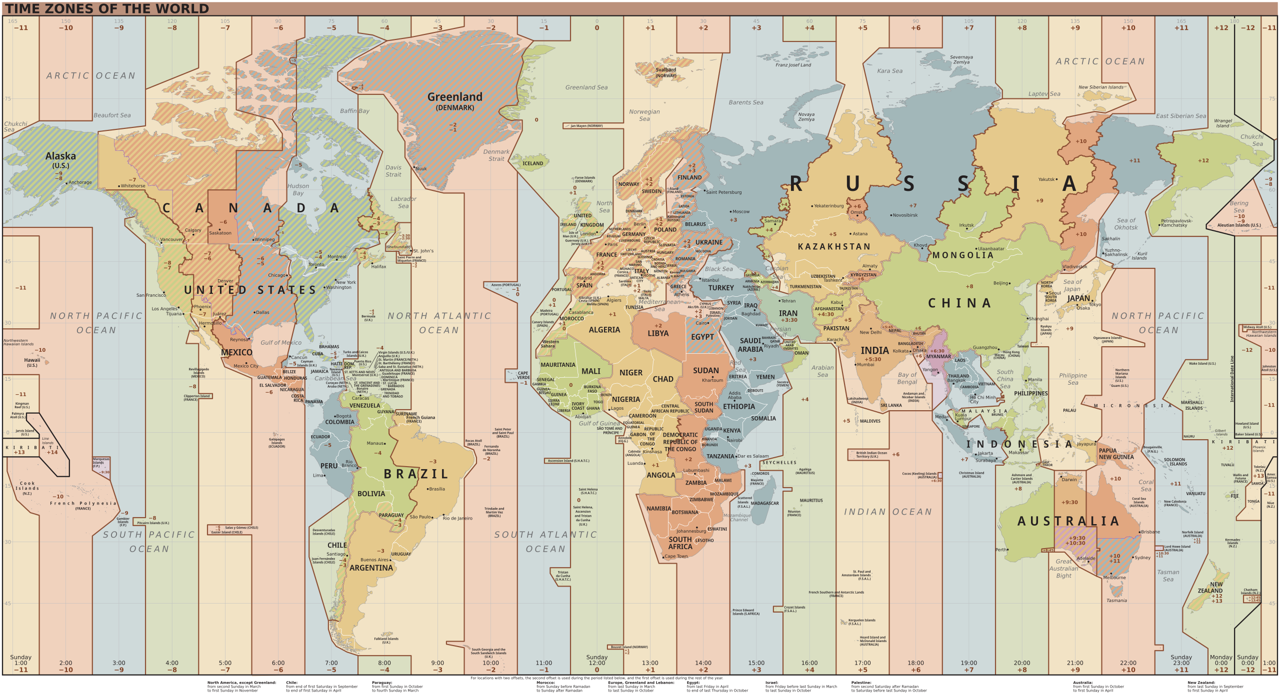
https://upload.wikimedia.org/wikipedia/commons/e/ec/World_Time_Zones_Map.svg
Take, say, UTC+8, to pick one arbitrary zone.
They misspoke and bizarrely doubled down when corrected, but they are touching upon an interesting fun fact. That it’s always daytime somewhere in France.
The sun never sets on the French empire
[Sad roast beef noises]
I didn’t realize French territory is so widespread.
So if the U.K. ever complies with the UN and the ICJ and relinquishes control of the Chagos Islands to Mauritius, the sun will set on the British empire, but not on France.
That’ll be funny as fuck and I hope France never misses an opportunity to point it out.
It is in the most timezones of any country, so I expect that that’s the idea they were half-remembering
that’s some dedication here
There’s pretty much nothing right along the international date line, regardless of country. If you’re trying to collect them all you better not care about +12 vs -12. As you can see your options are also limited for -1 and -2.
Unrelatedly, I’m curious what the story is with Central vs. Mountain time in Nunavut. That’s quite the wasp-waist for such a vast, mostly empty area.
If you’re trying to collect them all you better not care about +12 vs -12.
And thus it was that France invaded New Zealand’s Chatham Islands and the United States Minor Outlying Islands.
Instead of grabbing the Azores for UTC -1, France figured it would be easier to just annex all of Portugal. Brazil was reportedly grateful to no longer have a whole extra timezone for that one -2 island, and also glad to hear that they annexed Portugal.
If you‘re so picky, I‘ll as well. I wrote it spans across, not includes all.
But what does that mean? Does Australia span all timezones? Take its zone of UTC+9:30 and then go all the way around the globe to the east until you hit UTC+8 which is also Australia. Congrats you passed through all timezones and are in Australia again.
So you only need 2 areas in 2 time zones and boom you span all of them? How would you define “span” for something like this on a globe?
Yeah, agreed. Span = bridge. It’s gotta be contiguous across all timezones. Otherwise it’s a fact that France exists in many timezones, but not all.
Still an impressive graphic.
730 bananas?
Reading fail


.svg)