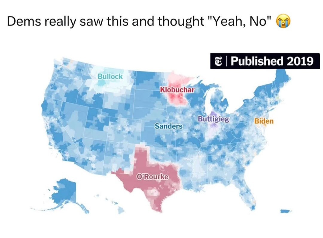
Cali in this picture is quite distinctly pale and white in densely populated regions. Compare.
The message of the map is quite clearly not “Cali is voting for Bernie, look at how overwhelming that is!”, but using the physical size of the country and Bernie’s support in low-density states to portray him as winning an overwhelming victory, when Bernie’s frontrunner status at this point was a fairly slim plurality.
Yep. It would’ve been nice if more people who weren’t braindead ghouls chose to show up to the primaries and vote, but I guess they had more important things to do on that day, like jerking off.
They’re talking about traitor lunatics who complain that a mostly red map (traitor lunatic counties) doesn’t result in a traitor lunatic victory. It’s the whole “people live in cities” joke.
Sorry about that. I was being cheeky but serious. Here it is in English:
They’re talking about Republicans/right wingers who complain when a mostly red looking map (Republican won counties) doesn’t result in a Republican victory. It’s the whole “people live in cities” joke.
So what happens is, these folks look at a map of the US that’s divided into counties and they see these enormous swaths of red, but a Democrat has won, and they—100% in earnest—say that it’s evidence that the election is stolen. That’s why we respond with “land doesn’t vote” and “people live in cities”.
The maps are as misleading as a Verizon coverage map. And Kornacki at the board saying it really only matters for the counties that have millions of votes vs all the tiny counties that come in immediately cause they have 10,000 people living there.
I think the problem is that we have accept these counties do matter though. A state being 3 blue and the rest red even if it’s where everyone lives is blue means that the land is voting. Very heavily too. And stuff like electoral votes being so many for this less populated land means we have to take it into account. So losing 1,000 battles but losing the war sounds like losing to me.
Bernie was never going to win the deep-red states on the strength of his primary polling.
Land doesn’t vote in the Dem primaries.
The implication of these maps is to present one candidate or party or idea as overwhelmingly popular, when it’s just color-by-the-numbers for largely empty space.
It is the low density states that make it so much easier for the Republicans to win especially when the Democrats avoid them and people call it empty.
Those states that are “empty” are always half of the electoral votes.
Also don’t do statistics for a thing we don’t have any data for we don’t know how he would have performed cause it’s not just simple math it’s real life and we never got to, nor will we ever know.
It’s tracing where candidates predominate, with blue and deep blue being Sanders - the impression is given, by the presence of blue across a large swathe of the country, that Sanders is winning an overwhelming victory. However, much of the area that is blue is not considerably populated; while Sanders enjoyed plurality support at this point in the primary (I remember it well, because I was so fucking excited and hopeful), it’s not even vaguely close to the implication of overwhelming support that the map gives off.

Great, now we’re doing “land votes” takes just like conservative boomers posting minion memes on Facebook.
I’m so glad to see that the ‘left’ isn’t as fucking braindead as the ghouls on the right. /s
You do see California all blue, right? That’s 10% of the population of the US, just right there.
California, New York, and Florida are in no way just land.
Cali in this picture is quite distinctly pale and white in densely populated regions. Compare.
The message of the map is quite clearly not “Cali is voting for Bernie, look at how overwhelming that is!”, but using the physical size of the country and Bernie’s support in low-density states to portray him as winning an overwhelming victory, when Bernie’s frontrunner status at this point was a fairly slim plurality.
Yes, he was the front runner. The dems chose a losing fascist instead. There are your braindead ghouls.
Yep. It would’ve been nice if more people who weren’t braindead ghouls chose to show up to the primaries and vote, but I guess they had more important things to do on that day, like jerking off.
But the land does vote.
That’s the whole issue with gerrymandering and the electoral college.
They’re talking about traitor lunatics who complain that a mostly red map (traitor lunatic counties) doesn’t result in a traitor lunatic victory. It’s the whole “people live in cities” joke.
I don’t get it actually. I think you are relying on me getting some of those terms and I am not.
Sorry.
Sorry about that. I was being cheeky but serious. Here it is in English:
They’re talking about Republicans/right wingers who complain when a mostly red looking map (Republican won counties) doesn’t result in a Republican victory. It’s the whole “people live in cities” joke.
So what happens is, these folks look at a map of the US that’s divided into counties and they see these enormous swaths of red, but a Democrat has won, and they—100% in earnest—say that it’s evidence that the election is stolen. That’s why we respond with “land doesn’t vote” and “people live in cities”.
Does that make more sense?
Yup yup!
The maps are as misleading as a Verizon coverage map. And Kornacki at the board saying it really only matters for the counties that have millions of votes vs all the tiny counties that come in immediately cause they have 10,000 people living there.
I think the problem is that we have accept these counties do matter though. A state being 3 blue and the rest red even if it’s where everyone lives is blue means that the land is voting. Very heavily too. And stuff like electoral votes being so many for this less populated land means we have to take it into account. So losing 1,000 battles but losing the war sounds like losing to me.
Okay but:
Bernie was never going to win the deep-red states on the strength of his primary polling.
Land doesn’t vote in the Dem primaries.
The implication of these maps is to present one candidate or party or idea as overwhelmingly popular, when it’s just color-by-the-numbers for largely empty space.
But it’s not empty space?
It is the low density states that make it so much easier for the Republicans to win especially when the Democrats avoid them and people call it empty.
Those states that are “empty” are always half of the electoral votes.
Also don’t do statistics for a thing we don’t have any data for we don’t know how he would have performed cause it’s not just simple math it’s real life and we never got to, nor will we ever know.
Either Delaware has a population density to rival Kowloon Walled City, or this is a bit more than a “land votes” take
It’s tracing where candidates predominate, with blue and deep blue being Sanders - the impression is given, by the presence of blue across a large swathe of the country, that Sanders is winning an overwhelming victory. However, much of the area that is blue is not considerably populated; while Sanders enjoyed plurality support at this point in the primary (I remember it well, because I was so fucking excited and hopeful), it’s not even vaguely close to the implication of overwhelming support that the map gives off.
Let’s see the map for kamalacaust then? lmao.
The fuck does Harris have to do with what I’m saying?
California, New York, and Illinois are land votes?
No, the vast majority of the map is empty land.
So you’re mad at the population distribution of the USA? I guess you gotta blame something for your gross candidate and pathetic loss.
… what